A collaboration between the Dutch Cadastre (Kadaster) and the European Union Agency for Railways (ERA).
Linked data is becoming more important as an integrated way of publishing large-scale governmental datasets. Because linked data is based on open standards, it is possible to utilize the data disclosed in the these datasets across organizational as well as across national borders.
This data story presents insights from the following linked data sources:
- ERA KG, published by ERA, contains information about railway-related objects in the EU.
- Base Registry of Topography (BRT), published by Kadaster, contains information about geospatial objects in The Netherlands. This includes geospatial information about stations and railroads.
The goal of this data story is to explore the similarities and differences between these two linked datasets. The scope of this data story is to take two topics of interest:
- Information about train stations.
- Information about the number of tracks.
1. Stations
The ERA KG contains detailed administrative information about all train stations in the EU. However, the geospatial information about these train stations is relatively simple because only a point geometry is available.
The BRT has detailed polygons for every building in The Netherlands, including station buildings.
Here we see an opportunity to combine information from both sources to deliver a more complete picture.
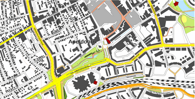
Figure 1. Stations in BRT (purple) and operational points in ERA KG (orange).
Unfortunately, the station in BRT and the operational points in ERA KG do not use common identifiers. We therefore do not know for certain whether two objects are the same or not across datasets. However, we can try to geospatially link station buildings from BRT to operational points in ERA KG.
We use the GeoSPARQL function geof:sfWithin(?era, ?brt)) to achieve this.
Figure 2. Railway stations that are geospatially linked between BRT (purple) and ERA KG (orange).
There is a difference between specific information and description of the stations among ERA KG and BRT, Thus the BRT specify station as typeGebouw:stationsgebouw and registered as a gebouw, basing on BAG . Most of the time, the station building from BRT has also multiple types, typeGebouw:stadskantoor_hulpsecretarie. So the BRT is specifying and consider stations as buildings with different purpose, while in ERA KG the stations are described as specific railway infrastructure. Thus, the information about the station in ERA KG contains such data as number of tracks, gauge etc. That could be also of interest for Kadaster.
Table 1.
2. Railroads and tracks
The representation of the railways in BRT and ERA KG are different. The number of tracks and detailed information is linked to the station in ERA. While the railroads in BRT are the line objects, have their own geometry. At the same time, the information about the tracks is more detailed in ERA than in BRT. The Base Registry Topography (BRT) contains only 3 types of the railways: one, two and more tracks. BRT provides a nice overview with geometry and correct location of the tracks.
To find more detailed information, we can look at ERA data. Thus, as can be seen from the picture, the total number of the tracks within the Netherlands is varying. There is a place with 130 tracks - Kijfhoek between Rotterdam en Dordrecht.
Figure 3. The number of tracks per operational point in The Netherlands according to ERA KG.
If we would like to search for the places with the 2 track railroads, we could find 100 stations.
Legend:
- green = single track
- orange = double track
- red = multiple tracks
Figure 4. The number of tracks for railways in the Netherlands according to BRT (lines) and ERA KG (points).
The information about railroad tracks in ERA KG is more detailed and each track has its own ID and platform information.
Table 2. Information about a rail track.
Possible ideas for the future collaboration:
- exploration of the data enrichment, routes from ERA with the railway information from BRT (and vice versa);
- linking stations from BRT with the stations from ERA and populate with the more detailed information;
- connecting route points (operational points) with the stations from BRT.