With this data story, we would like to demonstrate the range of ways in which geographical names in the context of the Netherlands have been included and can be identified in the Kadaster Knowledge Graph (KKG). For a complete overview of the modelling and development approach taken in developing the Kadaster Knowledge Graph, please visit the Kadaster Data Science Team's lab environment.
Additional Building Names
The following table provides a list of all buildings with an additional name aside from a given address as well as the usage or function of the building at this point in time. The results can be filtered per town in the Netherlands by inputting different names into the 'town' input box. As you can see, many of the results are offices, hospitals, shops or university buildings.
Table 1: Addresses, building names and functions for buildings within a given administrative area
Administrative Areas
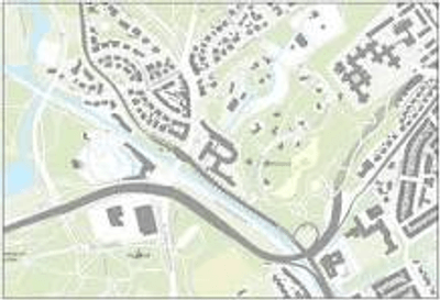
On the map below, all districts and neighbourhoods within a given town are displayed. If you click on the polygon, a pop will be shown with the names of each.
Map 1: Map displaying all neighbourhoods and districts within a given town
Religious Buildings - KKG and Wikidata
The following provides a list of religious buildings in the Netherlands, their building years and a picture of the building from Wikidata.
Religious buildings in the Netherlands with Wikidata images
Kadaster Knowledge Graph and Geonames NL/BE
The following table show results of a query which combines information from the KKG with information about a place from Geonames and provides all alternative names for a given place in a table.